While astronomers spend most of their careers looking up at the night sky, the very same analysis techniques that are used to explore the universe can be used to explore planet Earth. Remote sensed images are powerful tools in sustainable development. They can be used to measure deforestation and dwindling freshwater resources, or to monitor atmospheric composition and economic development.
Dr Tom Mutabazi is a lecturer at Mbarara University of Science & Technology in Uganda and has been working as a remote fellow with the Office of Astronomy for Development to explore both the advantages and the technical challenges that come with moving from an astronomy background to research in remote sensing. Tom has a PhD in Astronomy from the University of Cape Town in South Africa, where he analysed infrared and optical images of galaxies. He is now transferring the skills he developed there, and applying them to Landsat and Sentinel images of Uganda. Tom is using his background in infrared imaging, alongside the techniques in scripting and programming, to explore how Uganda’s vegetation health has changed over the last decade, and to measure the quality of freshwater in large water bodies such as Lake Victoria.
In many universities of the global South, investment in blue-skies sciences like Astronomy is driven only by their potential to impact more broadly on socioeconomic development. Using this model of skills transfer between astronomy and remote sensing may help to drive future progress in both fields.
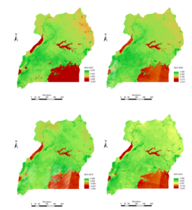
Snapshots of the normalised difference vegetation index (NDVI) from Landsat images of Uganda over the years from 2001 to 2014. Darker green shows healthier vegetation.